SDSC Assists Researchers in Novel Wildlife Tracking Project
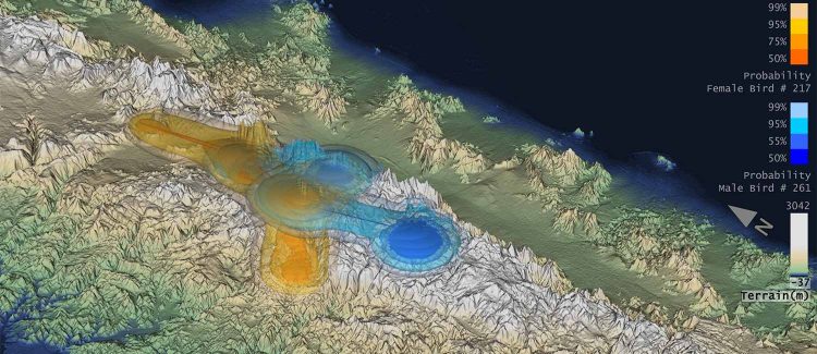
An image from a sequence of visualizations from analysis to identify home range in 3D of California Condors. The blue and orange colored surfaces show probabilities of male and female birds, respectively. Source: Amit Chourasia, Jeff Tracey, James Sheppard, Glen Lockwood, Mahidhar Tatineni, Robert N. Fisher, and Robert Sinkovits. Collaborative work between the San Diego Supercomputer Center, San Diego Zoo, and U.S. Geological Survey.
A team including researchers from the U.S. Geological Survey (USGS) and the San Diego Zoo’s Institute for Conservation Research has developed a novel methodology that for the first time combines 3D and advanced range estimator technologies to provide highly detailed data on the range and movements of terrestrial, aquatic, and avian wildlife species.
A paper detailing the project, called ‘Movement-based Estimation and Visualization of Space Use in 3D for Wildlife Ecology and Conservation’, was published July 2 in the PLoS-ONE online science journal. A video of the project can be viewed on SeedMe at https://www.seedme.org/condor_vis.
From Days to Minutes
“We were able to speed up their software by several orders of magnitude,” said Robert Sinkovits, SDSC’s Director of the Scientific Applications Group, which helps researchers make optimal use of SDSC's larger supercomputers, including Gordon and Trestles. “In this case, calculations that had formerly taken four days to complete were finished in less than half an hour.”
What started as a supercomputing challenge – since 3D modeling is much more computationally data intensive than 2D – actually became an exercise in optimizing codes that makes it possible for the current problems of interest to be done on laptops or even smart phones.
“While the researchers with the San Diego Zoo and USGS came to SDSC for our supercomputing, they stayed for our expertise,” said Sinkovits. “We welcome them to use both our systems and expertise to solve other challenges that were previously considered to be intractable.”
Gordon is being used to create interactive visualizations, and will make it easier for the software developers to explore the impact of algorithmic modifications on the quality of the solution.
The visualization expertise was provided by Amit Chourasia, senior visualization scientist at SDSC.
“We made changes to write the data into a more compact format, which enabled swift output and ingestion,” said Chourasia. “A key goal was to allow the experts to visualize the data directly on Gordon via remote access, as it is essential to minimize data movement and replication especially when data sizes grow. Currently, we’re working to fuse data from various sources such as topography and climate to further aid the understanding of such habitats.”
2D or Not 2D
“Our collaborative research team has created a novel and powerful tool for visualizing and modeling animal home ranges in 3D that harnesses the power of SDSC to fully exploit the increasing size and quality of 3D animal biotelemetry tracking and datasets,” said James Sheppard, a senior researcher within the Applied Animal Ecology Division of the San Diego Zoo’s Institute for Conservation Research, and a member of the research team. “This provides us with deeper insights into patterns of animal space-use and informs strategies for the conservation management of endangered species and their habitats.”
Specifically, the project’s advancement centered on the use of 3D technology for home range estimators, as opposed to traditional 2D systems typically used by ecologists. In a graphic image, the x and y axes denote width and height, while the z axis denotes depth, or vertical movement. The team developed what is called a movement-based kernel density estimator (MKDE) to estimate animal movements.
“We show that analyses and visualization using 3D MKDEs are more accurate and informative than traditional 2D estimators in representing the space use of animals that have a substantive vertical component, such as those that fly, traverse steep terrain, or dive in the water,” said Jeff Tracy, an ecologist at the USGS and lead author of the study.
“Biologists and ecologists are only beginning to recognize the value of incorporating the vertical aspect into analyses, which more realistically represents the space used by an animal,” added Tracy, who developed the key algorithm vital to this research.
California Condors
One aspect of the study focused on learning more about the range and movements of the California condor. While its population now stands at approximately 400 birds – up from only 22 in the mid- 1980s – conservation efforts to reintroduce this ecologically-important species to its former habitat in the mountains of California and Mexico have been hampered by a lack of understanding about condor movement patterns and habitat use. To address this, the San Diego researchers have been attaching miniaturized GPS biotelemetry units to every condor that it releases into the wild, to gather valuable tracking data.
“We have been calculating home ranges for the tracked condors in three dimensions for the first time using this GPS location data, and our novel density estimator was used to incorporate the vertical component of animal movements into projections of space-use,” said Sheppard.
Although the team successfully developed appropriate algorithms for creating 3D home ranges, actually extending animal home range volumes into 3D is computationally demanding, especially for animals tracked using highly accurate GPS telemetry devices for which high-resolution home ranges should be calculated to capitalize on the fine-scale location data collected.
“It is also highly computationally intensive to generate 3D home ranges from GPS telemetry data collected from animals that occupy habitats encompassing large areas, such as the California condors and giant pandas tracked in the wild by San Diego Zoo Global and its collaborators. These computing challenges are why researchers have typically only analyzed animal ranges in 2D up until now,” said Sheppard.
Using this 3D technology, researchers can link the resulting home range data to customized climate models of condor habitats, also in 3D, to generate high-resolution images of condor spatial behaviors, habitat use, and the climatic conditions that stimulate and modify condor movements.
“This data will be used as a predictive management tool to inform conservation efforts to restore condor populations, particularly with regard to emerging threats such as climate change and wind energy impacts,” added Sheppard.
Big Data and Ecology
On a broader note, Sheppard noted that the field of ecology is entering the era of 'Big Data' so it is imperative that new analytical and visualization tools be developed that can process, manage, and analyze these increasingly large and accurate multidimensional datasets acquired from biotelemetry tracking devices and remote sensing technologies. “Otherwise ecologists and conservation managers may literally not be able to see the forest for the trees,” he said.
Additional information on the project is at http://www.werc.usgs.gov/animalspace3d and a blogpost can be read here.
In addition to Tracy and Sheppard, researchers for the study included Jun Zhu (University of Wisconsin, Madison); Fuwen Wei (Chinese Academy of Science, Beijing); Ronald Swaisgood (San Diego Institute for Conservation Research); and Robert Fisher (USGS, San Diego).
The California Condor tracking part of the study was funded or supported by San Diego Zoological Global, the United States Fish and Wildlife Service, Sempra Energy, and Mexico-based organizations including Instituto Nacional de Ecologia, Comision Nacional Para El Conocimiento y Uso de la Biodiversidad, Secretaria de Medio Ambiente y Recursos Naturales, Wildcoast/Costasalvaje. The Giant Panda research was funded by the National Natural Science Foundation of China, Wildlife Experimental Platform of Chinese Academy of Sciences, and San Diego Zoo Global. Funding and support for the dugong research was provided by CRC Reef, Australian Research Council LIEF Scheme, and James Cook University.
Media Contact
All latest news from the category: Ecology, The Environment and Conservation
This complex theme deals primarily with interactions between organisms and the environmental factors that impact them, but to a greater extent between individual inanimate environmental factors.
innovations-report offers informative reports and articles on topics such as climate protection, landscape conservation, ecological systems, wildlife and nature parks and ecosystem efficiency and balance.


Newest articles

Superradiant atoms could push the boundaries of how precisely time can be measured
Superradiant atoms can help us measure time more precisely than ever. In a new study, researchers from the University of Copenhagen present a new method for measuring the time interval,…

Ion thermoelectric conversion devices for near room temperature
The electrode sheet of the thermoelectric device consists of ionic hydrogel, which is sandwiched between the electrodes to form, and the Prussian blue on the electrode undergoes a redox reaction…

Zap Energy achieves 37-million-degree temperatures in a compact device
New publication reports record electron temperatures for a small-scale, sheared-flow-stabilized Z-pinch fusion device. In the nine decades since humans first produced fusion reactions, only a few fusion technologies have demonstrated…

