NASA's Aqua Satellite Gets Infrared Hint on Tropical Depression 2
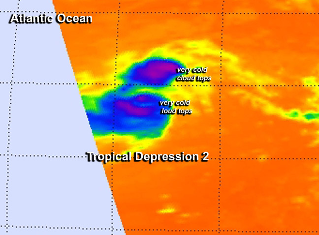
This false-colored infrared image on July 21 at 11:53 a.m. EDT from NASA's Aqua satellite shows some high, cold (purple) thunderstorm cloud tops in the low that became Tropical Depression 2. Image Credit: NASA JPL, Ed Olsen
NASA's Aqua satellite passed over System 92L on July 21 at 11:53 a.m. EDT and the Atmospheric Infrared Sounder (AIRS) instrument gathered infrared data on the developing low pressure area.
The infrared data shows temperature, and AIRS data showed some areas of very cold cloud top temperatures, exceeding the threshold of -63F/-52C that indicates cloud tops near the top of the troposphere.
Those cloud top temperatures are also indicative of strong uplift (of air) and powerful thunderstorms. Soon after the AIRS data was taken the low that became Tropical Depression 2.
At 11 a.m. EDT (1500 UTC) on July 222, the center of Tropical Depression Two (TD2) was located near latitude 12.6 north and longitude 48.0 west, about 910 miles (1,465 km) east of the Lesser Antilles.
Tropical Depression Two had maximum sustained winds near 35 mph (55 kph) but the National Hurricane Center (NHC) expects little change in strength over the next 24 hours.
The depression is moving toward the west near 17 mph (28 kph) and that general motion is expected to continue for the next couple of days. The estimated minimum central pressure is 1012 millibars.
The NHC noted that Tropical Depression 2 will be moving through an environment of dry air and increasing vertical wind shear that will not favor strengthening.
In fact, NHC forecasters expect that TD2 may weaken to a remnant low by Wednesday, July 23, and degenerate into a trough (elongated area) of low pressure on Thursday.
Text credit: Rob Gutro
NASA's Goddard Space Flight Center
Media Contact
More Information:
http://www.nasa.gov/content/goddard/td2-atlantic-ocean/All latest news from the category: Earth Sciences
Earth Sciences (also referred to as Geosciences), which deals with basic issues surrounding our planet, plays a vital role in the area of energy and raw materials supply.
Earth Sciences comprises subjects such as geology, geography, geological informatics, paleontology, mineralogy, petrography, crystallography, geophysics, geodesy, glaciology, cartography, photogrammetry, meteorology and seismology, early-warning systems, earthquake research and polar research.


Newest articles

Combatting disruptive ‘noise’ in quantum communication
In a significant milestone for quantum communication technology, an experiment has demonstrated how networks can be leveraged to combat disruptive ‘noise’ in quantum communications. The international effort led by researchers…

Stretchable quantum dot display
Intrinsically stretchable quantum dot-based light-emitting diodes achieved record-breaking performance. A team of South Korean scientists led by Professor KIM Dae-Hyeong of the Center for Nanoparticle Research within the Institute for…

Internet can achieve quantum speed with light saved as sound
Researchers at the University of Copenhagen’s Niels Bohr Institute have developed a new way to create quantum memory: A small drum can store data sent with light in its sonic…

