An earthquake in a maze
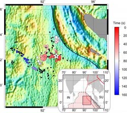
The colored circles on the large map indicate the complex spatial rupture pattern as a function of time during the Sumatra earthquake in April 2012. The white star indicates the epicenter of the magnitude-8.6 mainshock. The area shaded in darker red in the inset indicates the location of the area of study.<br><br>Credit: Caltech/Meng et al.<br>
The powerful magnitude-8.6 earthquake that shook Sumatra on April 11, 2012, was a seismic standout for many reasons, not the least of which is that it was larger than scientists thought an earthquake of its type could ever be.
Now, researchers from the California Institute of Technology (Caltech) report on their findings from the first high-resolution observations of the underwater temblor, they point out that the earthquake was also unusually complex—rupturing along multiple faults that lie at nearly right angles to one another, as though racing through a maze.
The new details provide fresh insights into the possibility of ruptures involving multiple faults occurring elsewhere—something that could be important for earthquake-hazard assessment along California's San Andreas fault, which itself is made up of many different segments and is intersected by a number of other faults at right angles.
“Our results indicate that the earthquake rupture followed an exceptionally tortuous path, breaking multiple segments of a previously unrecognized network of perpendicular faults,” says Jean-Paul Ampuero, an assistant professor of seismology at Caltech and one of the authors of the report, which appears online today in Science Express. “This earthquake provided a rare opportunity to investigate the physics of such extreme events and to probe the mechanical properties of Earth's materials deep beneath the oceans.”
Most mega-earthquakes occur at the boundaries between tectonic plates, as one plate sinks beneath another. The 2012 Sumatra earthquake is the largest earthquake ever documented that occurred away from such a boundary—a so-called intraplate quake. It is also the largest that has taken place on a strike-slip fault—the type of fault where the land on either side is pushing horizontally past the other.
The earthquake happened far offshore, beneath the Indian Ocean, where there are no geophysical monitoring sensors in place. Therefore, the researchers used ground-motion recordings gathered by networks of sensors in Europe and Japan, and an advanced source-imaging technique developed in Caltech's Seismological Laboratory as well as the Tectonics Observatory to piece together a picture of the earthquake's rupture process.
Lingsen Meng, the paper's lead author and a graduate student in Ampuero's group, explains that technique by comparing it with how, when standing in a room with your eyes closed, you can often still sense when someone speaking is walking across the room. “That's because your ears measure the delays between arriving sounds,” Meng says. “Our technique uses a similar idea. We measure the delays between different seismic sensors that are recording the seismic movements at set locations.” Researchers can then use that information to determine the location of a rupture at different times during an earthquake. Recent developments of the method are akin to tracking multiple moving speakers in a cocktail party.
Using this technique, the researchers determined that the three-minute-long Sumatra earthquake involved at least three different fault planes, with a rupture propagating in both directions, jumping to a perpendicular fault plane, and then branching to another.
“Based on our previous understanding, you wouldn't predict that the rupture would take these bends, which were almost right angles,” says Victor Tsai, an assistant professor of geophysics at Caltech and a coauthor on the new paper.
The team also determined that the rupture reached unusual depths for this type of earthquake—diving as deep as 60 kilometers in places and delving beneath the Earth's crust into the upper mantle. This is surprising given that, at such depths, pressure and temperature increase, making the rock more ductile and less apt to fail. It has therefore been thought that if a stress were applied to such rocks, they would not react as abruptly as more brittle materials in the crust would. However, given the maze-like rupture pattern of the earthquake, the researchers believe another mechanism might be in play.
“One possible explanation for the complicated rupture is there might have been reduced friction as a result of interactions between water and the deep oceanic rocks,” says Tsai. “And,” he says, “if there wasn't much friction on these faults, then it's possible that they would slip this way under certain stress conditions.”
Adding to the list of the quake's surprising qualities, the researchers pinpointed the rupture to a region of the seafloor where seismologists had previously considered such large earthquakes unlikely based on the geometry of identified faults. When they compared the location they had determined using source-imaging with high-resolution sonar data of the topography of the seafloor, the team found that the earthquake did not involve what they call “the usual suspect faults.”
“This part of the oceanic plate has fracture zones and other structures inherited from when the seafloor formed here, over 50 million years ago,” says Joann Stock, professor of geology at Caltech and another coauthor on the paper. “However, surprisingly, this earthquake just ruptured across these features, as if the older structure didn't matter at all.”
Meng emphasizes that it is important to learn such details from previous earthquakes in order to improve earthquake-hazard assessment. After all, he says, “If other earthquake ruptures are able to go this deep or to connect as many fault segments as this earthquake did, they might also be very large and cause significant damage.”
Along with Meng, Ampuero, Tsai, and Stock, additional Caltech coauthors on the paper, “An earthquake in a maze: compressional rupture branching during the April 11 2012 M8.6 Sumatra earthquake,” are postdoctoral scholar Zacharie Duputel and graduate student Yingdi Luo. The work was supported by the National Science Foundation, the Gordon and Betty Moore Foundation, and the Southern California Earthquake Center, which is funded by the National Science Foundation and the United States Geological Survey.
Written by Kimm Fesenmaier
Media Contact
More Information:
http://www.caltech.eduAll latest news from the category: Earth Sciences
Earth Sciences (also referred to as Geosciences), which deals with basic issues surrounding our planet, plays a vital role in the area of energy and raw materials supply.
Earth Sciences comprises subjects such as geology, geography, geological informatics, paleontology, mineralogy, petrography, crystallography, geophysics, geodesy, glaciology, cartography, photogrammetry, meteorology and seismology, early-warning systems, earthquake research and polar research.


Newest articles

High-energy-density aqueous battery based on halogen multi-electron transfer
Traditional non-aqueous lithium-ion batteries have a high energy density, but their safety is compromised due to the flammable organic electrolytes they utilize. Aqueous batteries use water as the solvent for…

First-ever combined heart pump and pig kidney transplant
…gives new hope to patient with terminal illness. Surgeons at NYU Langone Health performed the first-ever combined mechanical heart pump and gene-edited pig kidney transplant surgery in a 54-year-old woman…

Biophysics: Testing how well biomarkers work
LMU researchers have developed a method to determine how reliably target proteins can be labeled using super-resolution fluorescence microscopy. Modern microscopy techniques make it possible to examine the inner workings…

