Source of Galapagos eruptions is not where models place it
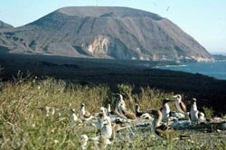
Birds flock not far from a volcano on Isabella Island, where two still active volcanoes are located. The location of the mantle plume, to the southeast of where computer modeling had put it, may explain the continued activity of volcanoes on the various Galapagos Islands.<br><br>Credit: Douglas Toomey<br>
Images gathered by University of Oregon scientists using seismic waves penetrating to a depth of 300 kilometers (almost 200 miles) report the discovery of an anomaly that likely is the volcanic mantle plume of the Galapagos Islands. It's not where geologists and computer modeling had assumed.
The team's experiments put the suspected plume at a depth of 250 kilometers (155 miles), at a location about 150 kilometers (about 100 miles) southeast of Fernandina Island, the westernmost island of the chain, and where generations of geologists and computer-generated mantle convection models have placed the plume.
The plume anomaly is consistent with partial melting, melt extraction, and remixing of hot rocks and is spreading north toward the mid-ocean ridge instead of, as projected, eastward with the migrating Nazca plate on which the island chain sits, says co-author Douglas R. Toomey, a professor in the UO's Department of Geological Sciences.
The findings — published online Jan. 19 ahead of print in the February issue of the journal Nature Geoscience — “help explain why so many of the volcanoes in the Galapagos are active,” Toomey said.
The Galapagos chain covers roughly 3,040 square miles of ocean and is centered about 575 miles west of Ecuador, which governs the islands. Galapagos volcanic activity has been difficult to understand, Toomey said, because conventional wisdom and modeling say newer eruptions should be moving ahead of the plate, not unlike the long-migrating Yellowstone hotspot.
The separating angles of the two plates in the Galapagos region cloud easy understanding. The leading edge of the Nazca plate is at Fernandina. The Cocos plate, on which the islands' some 1,000-kilometer-long (620-miles) hotspot chain once sat, is moving to the northeast.
The suspected plume's location is closer to Isabella and Floreana islands. While a dozen volcanoes remain active in the archipelago, the three most volatile are Fernandina's and the Cerro Azul and Sierra Negra volcanoes on the southwest and southeast tips, respectively, of Isabella Island, the archipelago's largest landmass.
The plume's more southern location, Toomey said, adds fuel to his group's findings, at three different sites along the globe encircling mid-ocean ridge (where 85 percent of Earth's volcanic activity occurs), that Earth's internal convection doesn't always adhere to modeling efforts and raises new questions about how ocean plates at the Earth's surface — the lithosphere — interact with the hotter, more fluid asthenosphere that sits atop the mantle.
“Ocean islands have always been enigmatic,” said co-author Dennis J. Geist of the Department of Geological Sciences at the University of Idaho. “Why out in the middle of the ocean basins do you get these big volcanoes? The Galapagos, Hawaii, Tahiti, Iceland — all the world's great ocean islands – they're mysterious.”
The Galapagos plume, according to the new paper, extends up into shallower depths and tracks northward and perpendicular to plate motion. Mantle plumes, such as the Galapagos, Yellowstone and Hawaii, generally are believed to bend in the direction of plate migration. In the Galapagos, however, the volcanic plume has decoupled from the plates involved.
“Here's an archipelago of volcanic islands that are broadly active over a large region, and the plume is almost decoupled from the plate motion itself,” Toomey said. “It is going opposite than expected, and we don't know why.”
The answer may be in the still unknown rheology of the gooey asthenosphere on which the Earth's plates ride, Toomey said. In their conclusion, the paper's five co-authors theorize that the plume material is carried to the mid-ocean ridge by a deep return flow centered in the asthenosphere rather than flowing along the base of the lithosphere as in modeling projections.
“Researchers at the University of Oregon are using tools and technologies to yield critical insights into complex scientific questions,” said Kimberly Andrews Espy, vice president for research and innovation and dean of the UO Graduate School. “This research by Dr. Toomey and his team sheds new light on the volcanic activity of the Galapagos Islands and raises new questions about plate tectonics and the interaction between the zones of the Earth's mantle.”
Co-authors with Toomey and Geist were: doctoral student Darwin R. Villagomez, now with ID Analytics in San Diego, Calif.; Emilie E.E. Hooft of the UO Department of Geological Sciences; and Sean C. Solomon of the Lamont-Doherty Earth Observatory at Columbia University.
The National Science Foundation (grants OCE-9908695, OCE-0221549 and EAR-0651123 to the UO; OCE-0221634 to the Carnegie Institution of Washington and EAR-11452711 to the University of Idaho) supported the research.
About the University of Oregon
The University of Oregon is among the 108 institutions chosen from 4,633 U.S. universities for top-tier designation of “Very High Research Activity” in the 2010 Carnegie Classification of Institutions of Higher Education. The UO also is one of two Pacific Northwest members of the Association of American Universities.
Source: Douglas R. Toomey, professor of geophysics, Department of Geological Sciences, 541-346-5576, drt@uoregon.edu
Links:
Toomey faculty page: http://pages.uoregon.edu/drt/
Department of Geological Science: http://geology.uoregon.edu/
Follow UO Science on Facebook: http://www.facebook.com/UniversityOfOregonScience
UO Science on Twitter: http://twitter.com/UO_Research
More UO Science/Research News: http://uoresearch.uoregon.edu
Note: The University of Oregon is equipped with an on-campus television studio with a point-of-origin Vyvx connection, which provides broadcast-quality video to networks worldwide via fiber optic network. In addition, there is video access to satellite uplink, and audio access to an ISDN codec for broadcast-quality radio interviews.
Media Contact
More Information:
http://www.uoregon.eduAll latest news from the category: Earth Sciences
Earth Sciences (also referred to as Geosciences), which deals with basic issues surrounding our planet, plays a vital role in the area of energy and raw materials supply.
Earth Sciences comprises subjects such as geology, geography, geological informatics, paleontology, mineralogy, petrography, crystallography, geophysics, geodesy, glaciology, cartography, photogrammetry, meteorology and seismology, early-warning systems, earthquake research and polar research.


Newest articles

Silicon Carbide Innovation Alliance to drive industrial-scale semiconductor work
Known for its ability to withstand extreme environments and high voltages, silicon carbide (SiC) is a semiconducting material made up of silicon and carbon atoms arranged into crystals that is…

New SPECT/CT technique shows impressive biomarker identification
…offers increased access for prostate cancer patients. A novel SPECT/CT acquisition method can accurately detect radiopharmaceutical biodistribution in a convenient manner for prostate cancer patients, opening the door for more…

How 3D printers can give robots a soft touch
Soft skin coverings and touch sensors have emerged as a promising feature for robots that are both safer and more intuitive for human interaction, but they are expensive and difficult…

