NASA Spots Very Heavy Rainfall Rates in Tropical Cyclone Edilson
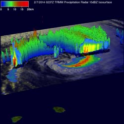
TRMM rainfall data on Feb. 7, 2014 showed Edilson south of La Reunion and Mauritius Islands dropping its heaviest rain at a rate of over 175mm/~6.9 inches per hour (red). <br>Image Credit: SSAI/NASA, Hal Pierce<br>
The Tropical Rainfall Measuring Mission or TRMM satellite is managed by both NASA and the Japan Aerospace Exploration Agency called JAXA. TRMM can read the rate in which rain is falling on Earth while in its orbit high above.
The TRMM satellite had an excellent early morning look at Edilson on February 7, 2014 at 0237 UTC/06:28 local time when it passed directly above the tropical cyclone. A rainfall analysis from TRMM's Microwave Imager (TMI) and Precipitation Radar (PR) instruments was overlaid on an enhanced visible/infrared image from TRMM's Visible and InfraRed Scanner (VIRS) at NASA's Goddard Space Flight Center in Greenbelt, Md. to create a total picture of the storm.
Rainfall data showed Edilson south of La Reunion and Mauritius Islands dropping its heaviest rain at a rate of over 175mm/~6.9 inches per hour in an intense feeder band on the eastern side of the tropical cyclone.
TRMM's PR data sliced through Edilson providing data for a 3-D look inside the tropical cyclone. Those data revealed that the highest thunderstorm tops, reaching heights over 14.75km/~9.1 miles were also located in the feeder band east of Edilson's center of circulation.
At 1500 UTC/10 a.m. EST on February 7, the Joint Typhoon Warning Center or JTWC noted that Edilson was located near 29.7 south and 53.9 east, about 508 nautical miles/584.6 miles/940.8 km south of Saint Denis. Edilson's maximum sustained winds were near 50 knots/57 mph/92.6 kph. The tropical storm is moving to the south-southwest at 16 knots/18.4 mph/29.6 kph.
Since the TRMM satellite passed over Edilson, the strongest thunderstorms have weakened as convection has decayed. That's because Edilson is now located within an upper-level shortwave trough (elongated area of low pressure) and is being battered with strong northerly vertical wind shear between 20 and 30 knots/23.0 to 34.5 mph/37.0 to 55.5 kph).
Edilson is expected to continue on a southerly track over the next several days as it becomes extra-tropical over open waters of the Southern Indian Ocean.
Text credit: Hal Pierce/Rob Gutro
SSAI/NASA's Goddard Space Flight Center
Media Contact
All latest news from the category: Earth Sciences
Earth Sciences (also referred to as Geosciences), which deals with basic issues surrounding our planet, plays a vital role in the area of energy and raw materials supply.
Earth Sciences comprises subjects such as geology, geography, geological informatics, paleontology, mineralogy, petrography, crystallography, geophysics, geodesy, glaciology, cartography, photogrammetry, meteorology and seismology, early-warning systems, earthquake research and polar research.


Newest articles

Properties of new materials for microchips
… can now be measured well. Reseachers of Delft University of Technology demonstrated measuring performance properties of ultrathin silicon membranes. Making ever smaller and more powerful chips requires new ultrathin…

Floating solar’s potential
… to support sustainable development by addressing climate, water, and energy goals holistically. A new study published this week in Nature Energy raises the potential for floating solar photovoltaics (FPV)…

Skyrmions move at record speeds
… a step towards the computing of the future. An international research team led by scientists from the CNRS1 has discovered that the magnetic nanobubbles2 known as skyrmions can be…

