NASA Sees Cyclone Gino Wind Up to Wind Down Later
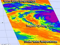
On Feb. 12 at 0841 UTC, NASA AIRS instrument infrared imagery showed that Cyclone Gino had developed a large area of very cold, high cloud top temperatures (purple) around its center indicating powerful thunderstorms. Credit: NASA JPL, Ed Olsen<br>
On Feb. 12 at 0841 UTC, NASA Atmospheric Infrared Sounder (AIRS) instrument that flies aboard the Aqua satellite captured infrared imagery of Cyclone Gino that showed the storm developed a large area of very cold, high cloud top temperatures around its center indicating powerful thunderstorms.
Cloud top temperatures were as cold as -63 Fahrenheit (-52 Celsius) indicating strong storms that have the capability to produce heavy rainfall. The AIRS imagery also suggests a ragged eye had formed.
On Feb. 12 at 1500 UTC (10 a.m. EST), Cyclone Gino's maximum sustained winds had increased to 75 knots (86.3 mph/138.9 kph) making the storm a category one hurricane. Gino was centered near 17.1 south latitude and 79.5 east longitude, about 700 nautical miles (805.5 miles/1,296 km) southeast of Diego Garcia.
Gino has been moving to the south-southwest at 10 knots (11.5 mph/18.5 kph), around the northwestern edge of a subtropical ridge (elongated area) of high pressure.
AIRS data shows that the sea surface temperatures around Gino are currently favorable for further development because they're around a warm 28 degrees Celsius (82.4 Fahrenheit). However, as Gino moves further south-southwest, those sea surface temperatures will drop, making it more difficult for the tropical cyclone to maintain intensity.
In addition, wind shear is expected to increase over the next three days as Gino moves further south. The Joint Typhoon Warning Center expects Gino to transition to a cold core low pressure area by Feb. 15.
Text Credit: Rob Gutro
NASA's Goddard Space Flight Center
Media Contact
All latest news from the category: Earth Sciences
Earth Sciences (also referred to as Geosciences), which deals with basic issues surrounding our planet, plays a vital role in the area of energy and raw materials supply.
Earth Sciences comprises subjects such as geology, geography, geological informatics, paleontology, mineralogy, petrography, crystallography, geophysics, geodesy, glaciology, cartography, photogrammetry, meteorology and seismology, early-warning systems, earthquake research and polar research.


Newest articles

Making diamonds at ambient pressure
Scientists develop novel liquid metal alloy system to synthesize diamond under moderate conditions. Did you know that 99% of synthetic diamonds are currently produced using high-pressure and high-temperature (HPHT) methods?[2]…

Eruption of mega-magnetic star lights up nearby galaxy
Thanks to ESA satellites, an international team including UNIGE researchers has detected a giant eruption coming from a magnetar, an extremely magnetic neutron star. While ESA’s satellite INTEGRAL was observing…

Solving the riddle of the sphingolipids in coronary artery disease
Weill Cornell Medicine investigators have uncovered a way to unleash in blood vessels the protective effects of a type of fat-related molecule known as a sphingolipid, suggesting a promising new…

