NASA's Infrared Satellite Imagery Shows Wind Shear Affecting Cyclone Ian
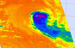
NASA's Aqua satellite passed over Ian on January 13 at 01:23 UTC and saw strongest storms with the coldest cloud tops had temperatures (purple) east and southeast of the center. <br>Image Credit: NASA JPL, AIRS<br>
On January 13 at 0900 UTC/4 a.m. EST, Tropical Cyclone Ian's maximum sustained winds were near 65 knots/74.8 mph/120.4 kph, just at hurricane-strength. Just a day before, Ian's maximum sustained winds were near 80 knots/148.2 kph/92.0 mph.
Ian is moving to the southeast at 14 knots/25.9 kph/16.1 mph and is expected to continue in that direction. Ian was located about 882 nautical miles/1,633 km/1,015 miles south of Pago Pago, near 29.5 south and 169.9 west.
Ian has become significantly elongated as it has been battling strong wind shear. The precipitation has also been sheared to the east.
When NASA's Aqua satellite passed over Ian on January 13 at 01:23 UTC/January 12 at 8:23 p.m. EST, the Atmospheric Infrared Sounder or AIRS instrument captured an infrared picture of the storm. Infrared data showed the temperature of the storm's clouds and the sea surface temperatures surrounding it. The strongest storms with the coldest cloud tops had temperatures as cold as -63F/-52C and the AIRS image showed those storms were clearly pushed east and southeast of the center. The AIRS data also showed warmer, lower cloud top temperatures north and west of Ian's center.
AIRS data showed sea surface temperatures north of Ian were as warm as 300K/26.5C/80.3F/ while those south of Ian (and in the general direction the storm was heading) were near 290K/16.8C/62.3F or cooler.
Over the next couple of days, Ian is expected to become extra-tropical and a cold core low pressure area in the next day and a half.
Ian is no threat to land as it continues on its southeastern track.
Text credit: Rob Gutro
NASA's Goddard Space Flight Center
Media Contact
All latest news from the category: Earth Sciences
Earth Sciences (also referred to as Geosciences), which deals with basic issues surrounding our planet, plays a vital role in the area of energy and raw materials supply.
Earth Sciences comprises subjects such as geology, geography, geological informatics, paleontology, mineralogy, petrography, crystallography, geophysics, geodesy, glaciology, cartography, photogrammetry, meteorology and seismology, early-warning systems, earthquake research and polar research.


Newest articles

“Nanostitches” enable lighter and tougher composite materials
In research that may lead to next-generation airplanes and spacecraft, MIT engineers used carbon nanotubes to prevent cracking in multilayered composites. To save on fuel and reduce aircraft emissions, engineers…

Trash to treasure
Researchers turn metal waste into catalyst for hydrogen. Scientists have found a way to transform metal waste into a highly efficient catalyst to make hydrogen from water, a discovery that…

Real-time detection of infectious disease viruses
… by searching for molecular fingerprinting. A research team consisting of Professor Kyoung-Duck Park and Taeyoung Moon and Huitae Joo, PhD candidates, from the Department of Physics at Pohang University…

